Introduction: Exploring the Photographic Wonders of the Yorkshire Dales
Welcome to our comprehensive guide to the Yorkshire Dales – a haven for photographers and tourists alike, seeking to capture the essence of one of England’s most picturesque and diverse landscapes. From the tranquillity of serene valleys to the grandeur of historic landmarks, the Yorkshire Dales National Park offers a plethora of breathtaking scenes waiting to be discovered and immortalized through the lens.
Whether you’re a professional photographer looking for your next stunning landscape, an amateur keen to explore the delights of nature photography, or a visitor simply wanting to immortalize your journey through this remarkable region, our guide is tailored for you. We delve into the heart of each valley, uncovering the hidden gems and well-known spectacles that make the Yorkshire Dales a photographer’s paradise.
Our guide is meticulously crafted to ensure a comprehensive listing of the highlights the Dales have to offer. We explore the charming villages, majestic waterfalls, rolling meadows, and towering peaks, each with their own unique character and photographic allure. From the iconic Ribblehead Viaduct in Ribblesdale to the serene waters of Lake Semerwater in Raydale, every location is a testament to the natural and cultural richness of the Dales.
For those visiting the area, prepare to be enthralled by the diverse landscapes that have inspired artists and captivated visitors for centuries. Each valley we traverse offers its own narrative, steeped in history and splendour, promising an unforgettable experience.
So, grab your camera, and let’s embark on a journey through the Yorkshire Dales, where every turn brings a new vista, every village tells a story, and every moment is an opportunity to capture the extraordinary beauty of this quintessentially English countryside.
Wharfedale – A Photographic Journey Through Time and Nature

Bolton Abbey – Close to West Yorkshire

History: Bolton Abbey is steeped in history, dating back to the 12th century. Originally a monastery, it now stands as a testament to the region’s rich heritage.
Google Maps Link: Bolton Abbey on Google Maps
Key Features and Interest: The Abbey ruins, set against the backdrop of the River Wharfe and rolling hills, offer a unique blend of natural and architectural beauty. The stepping stones and nearby Strid Wood add layers of interest to the landscape.
Why Photographers Should Visit: It’s a haven for landscape photographers, with its stunning mix of ruins, woodlands, and water. The interplay of light through the Abbey’s arches and the serene river setting provide ample opportunities for both wide landscape shots and detailed compositions.
Grassington – beautiful Yorkshire village

History: This charming market town is the heart of Upper Wharfedale, known for its cobbled streets and traditional Yorkshire architecture, dating back centuries.
Google Maps Link: Grassington on Google Maps
Key Features and Interest: Grassington offers a picturesque view of rural Yorkshire life. Its narrow streets, lined with stone cottages and local shops, are a snapshot of historical England.
Why Photographers Should Visit: Ideal for street and architectural photography, Grassington provides an authentic experience of a bustling Yorkshire Dales market town. The annual Grassington Festival brings a burst of energy and color, perfect for dynamic, candid photography.
Linton Falls – idyllic rural landscape
History: Linton Falls, one of the largest waterfalls in the Dales, has been a focal point of the landscape for centuries, harnessing water power for various mills.
Google Maps Link: Linton Falls on Google Maps
Key Features and Interest: The falls are a dynamic feature of the River Wharfe, offering spectacular views of cascading water over limestone. The surrounding greenery and wildlife add to its charm.
Why Photographers Should Visit: It’s a prime spot for capturing the power and beauty of nature. The changing water levels offer diverse photographic opportunities, from raging torrents to gentle cascades.
Simon’s Seat – natural wonder high up the hills
History: Simon’s Seat is a prominent rocky outcrop offering panoramic views of the Dales, historically used as a vantage point.
Google Maps Link: Simon’s Seat on Google Maps
Key Features and Interest: From its summit, you can capture breathtaking views of Wharfedale and beyond. The ascent passes through varied landscapes, including heather moorland and ancient woodland.
Why Photographers Should Visit: The trek to Simon’s Seat is rewarded with some of the most expansive and stunning views in the Dales. It’s perfect for capturing dramatic landscapes and the ever-changing Yorkshire skies.
Wensleydale – A Blend of Natural Splendor and Cultural Heritage

Aysgarth Falls – one of the most popular photography spots in the Yorkshire

History: Aysgarth Falls comprises a series of spectacular waterfalls carved out over millennia, featured in famous films like Robin Hood: Prince of Thieves.
Google Maps Link: Aysgarth Falls on Google Maps
Key Features and Interest: The three-tiered waterfalls cascade through broad limestone steps, surrounded by woodland. Each tier offers a unique perspective, with viewing platforms for the upper, middle, and lower falls.
Why Photographers Should Visit: The falls provide dynamic and dramatic scenes for photography, especially after rain when the water volume creates a powerful spectacle. The surrounding woods also offer opportunities for wildlife and nature photography.
Hawes – always worth a visit
History: Hawes, the highest market town in England, is renowned for its rich history, traditional shops, and as the home of the famous Wensleydale cheese.
Google Maps Link: Hawes on Google Maps
Key Features and Interest: The town’s picturesque streets and historic buildings are set against the backdrop of the stunning Yorkshire Dales. The Wensleydale Creamery adds a unique cultural element to the town.
Why Photographers Should Visit: Hawes offers diverse photographic subjects, from charming street scenes to rural landscapes. The cheese-making process at the creamery can also be a unique subject for those interested in culinary photography.
Hardraw Force – one of Yorkshire’s most beautiful places

History: Hardraw Force is the highest single-drop waterfall in England, with water cascading down 100 feet from a limestone cliff.
Google Maps Link: Hardraw Force on Google Maps
Key Features and Interest: The waterfall is located within the grounds of the Green Dragon Inn, adding a quaint charm to the setting. The sheer drop and surrounding greenery create a stunning visual.
Why Photographers Should Visit: It’s an ideal location for photographers looking to capture the majesty of nature. The sheer scale of the waterfall is impressive, especially after heavy rainfalls, offering dramatic photo opportunities.
Wensleydale Creamery – Yorkshire dales most famous cheese!
History: The Creamery is the heart of Wensleydale cheese-making, a tradition dating back to the 12th century.
Google Maps Link: Wensleydale Creamery on Google Maps
Key Features and Interest: This is where the famous Wensleydale cheese is crafted, offering a glimpse into the culinary heritage of Yorkshire. The visitor center provides insights into the cheese-making process.
Why Photographers Should Visit: The Creamery offers a unique photographic subject, blending cultural and culinary themes. Capturing the cheese-making process and the Creamery’s surroundings can yield both dynamic and still-life compositions.
Swaledale – Where Tradition Meets the Untamed Yorkshire Landscape

Gunnerside Meadows

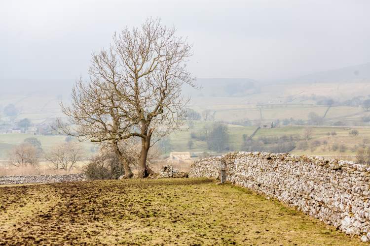
History: Gunnerside Meadows are synonymous with Swaledale’s agricultural heritage, known for their traditional hay meadows and dry stone walls.
Google Maps Link: Gunnerside Meadows on Google Maps
Key Features and Interest: During spring and early summer, the meadows burst into life with wildflowers, providing a vibrant tapestry of colors. The iconic stone barns scattered across the landscape add a unique historical dimension.
Why Photographers Should Visit: The meadows are a dream for landscape photographers, especially during the wildflower bloom. The combination of colorful flora, rustic barns, and rolling hills creates a quintessentially Yorkshire scene.
Reeth

History: Reeth, once a hub for the lead mining industry, is now a tranquil village surrounded by the stunning landscapes of Swaledale.
Google Maps Link: Reeth on Google Maps
Key Features and Interest: The village green, surrounded by shops, cafés, and historical buildings, is the heart of Reeth. The surrounding area offers impressive views of the Swaledale valley.
Why Photographers Should Visit: Reeth provides a charming blend of village life and natural landscapes. Its position in the valley makes it an ideal location for capturing both architectural and scenic photography.
Muker

History: Muker, once an important centre for the wool industry, is now a picturesque village famed for its stone-built structures and narrow lanes.
Google Maps Link: Muker on Google Maps
Key Features and Interest: Muker is renowned for its traditional meadows and well-preserved agricultural landscapes. The River Swale adds a dynamic element to the scenery.
Why Photographers Should Visit: Photographers can capture the essence of a traditional Yorkshire Dales village set against a backdrop of stunning natural beauty. The contrast between the cultivated meadows and wilder, natural river scenes is striking.
Keld

History: Keld, a small village in Swaledale, is known for its rich history linked to farming and lead mining, and as a crossing point for popular walking trails.
Google Maps Link: Keld on Google Maps
Key Features and Interest: Keld is surrounded by some of the most dramatic landscapes in the Dales, including waterfalls like Kisdon Force. It’s a convergence point for the Coast to Coast and Pennine Way walking routes.
Why Photographers Should Visit: The village is a prime spot for capturing the rugged beauty of the Dales. The nearby waterfalls and varied landscapes provide numerous opportunities for both landscape and nature photography.
Malhamdale – Malham is one of the most majestic spots in Yorkshire Dales National Park

Malham Cove

History: Malham Cove is a large curved limestone formation created by a waterfall carrying meltwater from glaciers over 12,000 years ago.
Google Maps Link: Malham Cove on Google Maps
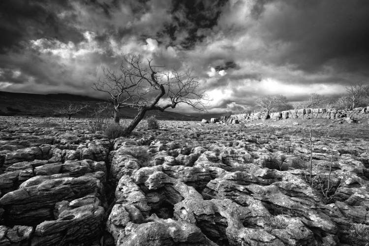
Key Features and Interest: The Cove features an 80-meter high cliff face and an extensive limestone pavement at the top, offering spectacular views. The area is also known for its unique flora and fauna.
Why Photographers Should Visit: It’s a paradise for landscape photographers, offering dramatic cliff views and intricate patterns in the limestone pavement. The Cove provides a dynamic landscape that changes with the light and weather, presenting endless photographic possibilities.
Gordale Scar

History: Gordale Scar is a dramatic limestone ravine formed by water erosion over thousands of years, with two waterfalls and overhanging cliffs.
Google Maps Link: Gordale Scar on Google Maps
Key Features and Interest: The Scar offers a rugged landscape with towering cliffs and cascading waterfalls. The natural rock amphitheater is both imposing and majestic.
Why Photographers Should Visit: This location is ideal for capturing the raw beauty of nature. The scale and drama of Gordale Scar provide a powerful backdrop for photographers seeking to capture the essence of the Yorkshire Dales’ wild side.
Janet’s Foss

History: Janet’s Foss is a small waterfall in a woodland setting, named after a local fairy tale about a queen of the fairies, Janet.
Google Maps Link: Janet’s Foss on Google Maps
Key Features and Interest: The waterfall flows into a clear pool, surrounded by lush greenery. The area is rich in woodland wildlife and offers a serene, mystical atmosphere.
Why Photographers Should Visit: Janet’s Foss is perfect for photographers looking for a peaceful, natural setting. The combination of the waterfall, woodland, and wildlife offers diverse photographic opportunities, from landscape to macro photography.
Malham Tarn

History: Malham Tarn is a glacial lake, one of only eight upland alkaline lakes in Europe, set in a designated National Nature Reserve.
Google Maps Link: Malham Tarn on Google Maps
Key Features and Interest: The Tarn is surrounded by limestone hills and unique flora. The area offers serene landscapes and a variety of birdlife.
Why Photographers Should Visit: Malham Tarn provides a tranquil setting for photographers. The reflections in the lake, especially at sunrise or sunset, create stunning photographic conditions. It’s also a great spot for wildlife and bird photography.
Ribblesdale – A Land of Majestic Landscapes and Yorkshire Dales Photography Beauty Spots

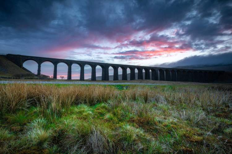
Ribblehead Viaduct

History: The Ribblehead Viaduct, completed in 1874, is an engineering marvel, part of the Settle-Carlisle railway line, featuring 24 massive stone arches.
Google Maps Link: Ribblehead Viaduct on Google Maps
Key Features and Interest: The viaduct spans the valley with the backdrop of the Yorkshire Three Peaks, offering a dramatic combination of human engineering and natural landscape.
Why Photographers Should Visit: It’s a must-visit for landscape photographers, offering an iconic view that captures the grandeur of Yorkshire’s engineering and natural heritage. The changing weather adds a dynamic element to the scene, ideal for dramatic photography.
Pen-y-ghent

History: Pen-y-ghent is one of the Yorkshire Three Peaks, with distinctive geological features and rich history, rising 694 meters above sea level.
Google Maps Link: Pen-y-ghent on Google Maps
Key Features and Interest: The peak offers panoramic views of Ribblesdale and the surrounding dales, with a variety of landscapes including limestone pavements and moorland.
Why Photographers Should Visit: The summit of Pen-y-ghent is an excellent location for capturing sweeping landscapes. The hike up the peak provides numerous opportunities to photograph the diverse terrain and vistas of the Yorkshire Dales.
Horton in Ribblesdale
History: Horton in Ribblesdale is a small village known for its role in quarrying and farming, and as a starting point for the Three Peaks Challenge.
Google Maps Link: Horton in Ribblesdale on Google Maps
Key Features and Interest: The village is characterized by traditional stone buildings and offers views of the surrounding limestone hills. It serves as a gateway to exploring the rugged landscapes of Ribblesdale.
Why Photographers Should Visit: Horton in Ribblesdale provides a quaint and authentic Yorkshire Dales experience. It’s an ideal spot for capturing rural life and serves as a base for photographing the surrounding dramatic landscapes.
Stainforth Force

History: Stainforth Force is a series of waterfalls on the River Ribble, near the historic village of Stainforth, known for its scenic beauty and salmon leaps.
Google Maps Link: Stainforth Force on Google Maps
Key Features and Interest: The falls offer a picturesque setting with cascading waters, especially during salmon migration in autumn. The surrounding woodland and wildlife add to its charm.
Why Photographers Should Visit: Stainforth Force is excellent for capturing the dynamic beauty of waterfalls and the natural environment. Autumn visits provide the added spectacle of salmon leaping, a unique photographic opportunity.
Littondale – A Serene Escape for the Photographer

Arncliffe

History: Arncliffe, the original setting for the TV series “Emmerdale,” is a picturesque village known for its traditional Dales architecture and tranquil atmosphere.
Google Maps Link: Arncliffe on Google Maps
Key Features and Interest: The village is centred around a beautiful green, with stone-built houses and the historic St. Oswald’s Church, offering a glimpse into traditional Dales life.
Why Photographers Should Visit: Arncliffe provides a perfect setting for capturing the essence of a peaceful Yorkshire Dales village, with its charming architecture and scenic surroundings.
Litton
History: Litton is a small, serene village tucked away in Littondale, known for its unspoiled landscapes and traditional Yorkshire charm.
Google Maps Link: Litton on Google Maps
Key Features and Interest: This quaint village is surrounded by rolling hills and pastoral scenes, offering an idyllic rural setting. It’s a lesser-known gem in the Dales, away from the usual tourist paths.
Why Photographers Should Visit: Litton is ideal for photographers seeking tranquil countryside scenes and authentic rural architecture. The peaceful environment allows for relaxed, contemplative photography.
Pen-y-ghent View

History: The view of Pen-y-ghent from Littondale offers a unique perspective of one of Yorkshire’s famous Three Peaks, showcasing its distinct shape and grandeur.
Google Maps Link: Pen-y-ghent View on Google Maps
Key Features and Interest: The viewpoint provides a stunning panorama of Pen-y-ghent, set against the backdrop of Littondale’s picturesque landscapes.
Why Photographers Should Visit: This vantage point is a must for landscape photographers, offering a postcard-perfect view of Pen-y-ghent, especially captivating during sunrise or sunset.
Foxup

History: Foxup is a hamlet in Littondale, epitomizing the tranquillity and natural beauty of the Yorkshire Dales, with a history rooted in farming and sheep-rearing.
Google Maps Link: Foxup on Google Maps
Key Features and Interest: The hamlet is surrounded by spectacular countryside, with traditional stone farmhouses and fields bordered by dry stone walls, offering a peaceful rural scene.
Why Photographers Should Visit: Foxup is perfect for capturing the timeless beauty of the Dales’ rural landscapes. The area’s simplicity and natural charm make it an ideal subject for landscape and nature photography.
Coverdale – A Hidden Gem in the Heart of the Yorkshire Dales
Carlton Town
History: Carlton Town is a charming, lesser-known village in Coverdale, with a rich history dating back to the Domesday Book.
Google Maps Link: Carlton Town on Google Maps
Key Features and Interest: The village features a mix of old stone houses and a picturesque church, set amidst rolling hills and pastoral landscapes.
Why Photographers Should Visit: Carlton Town offers a tranquil setting, ideal for capturing the essence of a traditional Yorkshire Dales village. Its off-the-beaten-path location means fewer crowds and more authentic scenes.
Coverham Abbey
History: Coverham Abbey, now in ruins, was once a thriving 12th-century Premonstratensian monastery, offering a glimpse into the area’s ecclesiastical past.
Google Maps Link: Coverham Abbey on Google Maps
Key Features and Interest: The Abbey ruins, set against the stunning backdrop of Coverdale’s countryside, provide a serene and historically rich photography subject.
Why Photographers Should Visit: The Abbey offers a unique opportunity to photograph historical ruins in a peaceful rural setting. The contrast between the ancient stones and the natural landscape makes for compelling compositions.
West Scrafton
History: West Scrafton is a small village in Coverdale, known for its traditional Yorkshire character and agricultural heritage.
Google Maps Link: West Scrafton on Google Maps
Key Features and Interest: The village is surrounded by beautiful countryside, with classic Dales scenery including stone barns and dry stone walls.
Why Photographers Should Visit: West Scrafton is an excellent location for photographers interested in capturing rural life and landscapes. The village’s untouched nature offers authentic and timeless photographic scenes.
Horsehouse
History: Horsehouse is a quaint village in Coverdale, named after its historic function as a resting place for packhorses.
Google Maps Link: Horsehouse on Google Maps
Key Features and Interest: The village is characterized by its charming church and traditional Yorkshire architecture, set in a peaceful and scenic location.
Why Photographers Should Visit: Horsehouse provides a peaceful escape, perfect for capturing the tranquil beauty of the Dales. The historical aspects of the village, combined with its picturesque setting, create a wonderful subject for both landscape and architectural photography.
Arkengarthdale – A Journey Through Rugged Landscapes and Quiet Villages

Langthwaite
History: Langthwaite, a small and picturesque village, is known for its role in the historic lead mining industry in Arkengarthdale.
Google Maps Link: Langthwaite on Google Maps
Key Features and Interest: This quaint village features charming stone cottages and a distinctive red phone box, set against a backdrop of stunning moorland and hills.
Why Photographers Should Visit: Langthwaite offers a perfect setting for capturing the traditional character of a Yorkshire Dales village, combined with the dramatic landscapes of Arkengarthdale.
Arkengarthdale Road
History: Arkengarthdale Road winds through some of the most remote and scenic parts of the Yorkshire Dales, offering breathtaking views and a sense of isolation.
Google Maps Link: Arkengarthdale Road on Google Maps
Key Features and Interest: The road provides panoramic views of the dale, with vast stretches of unspoiled landscapes, traditional stone barns, and the occasional glimpse of red grouse and other wildlife.
Why Photographers Should Visit: This route is ideal for landscape photographers seeking dramatic and expansive views. The changing light and weather conditions offer a constantly evolving photographic canvas.
CB Inn
History: The Charles Bathurst Inn, known as the CB Inn, is a renowned establishment in Arkengarthdale, offering a traditional Yorkshire welcome in a historic setting.
Google Maps Link: CB Inn on Google Maps
Key Features and Interest: The inn, surrounded by the rugged beauty of the dales, offers a picturesque and cozy setting, perfect for capturing the essence of a rural Yorkshire retreat.
Why Photographers Should Visit: The CB Inn and its surroundings provide a charming subject for photographers, with opportunities to capture both the historic architecture and the intimate details of traditional Yorkshire hospitality.
Waterfalls near Tan Hill

History: The area around Tan Hill, the highest pub in Britain, is known for its remote beauty and hidden waterfalls, tucked away in the rugged landscapes.
Google Maps Link: Waterfalls near Tan Hill on Google Maps
Key Features and Interest: The waterfalls, though smaller and lesser-known, offer a sense of discovery and tranquillity, set in one of the most remote parts of the Yorkshire Dales.
Why Photographers Should Visit: These waterfalls are perfect for photographers looking for off-the-beaten-path subjects. The isolation and natural beauty of the area make it a rewarding destination for landscape and nature photography.
Dentdale – A Valley of Timeless Charm and Natural Beauty

Dent Village
History: Dent Village, with its cobbled streets and quaint architecture, has a rich history that dates back to the 12th century.
Google Maps Link: Dent Village on Google Maps
Key Features and Interest: The village is known for its heritage buildings, including the 12th-century St. Andrew’s Church, and the traditional George & Dragon pub. The cobbled streets add a unique charm to the village.
Why Photographers Should Visit: Dent Village offers a picturesque setting for capturing the essence of a traditional Yorkshire Dales village. Its well-preserved architecture and narrow streets provide excellent opportunities for street and architectural photography.
Dentdale Trail

History: The Dentdale Trail is a scenic walking route that winds through the heart of the valley, showcasing the area’s natural beauty and rural landscapes.
Google Maps Link: Dentdale Trail on Google Maps
Key Features and Interest: The trail offers stunning views of the surrounding hills, meadows, and the River Dee. It’s a peaceful path that captures the tranquility of Dentdale.
Why Photographers Should Visit: This trail is ideal for landscape photographers, offering a variety of scenes from rolling hills to river landscapes. The changing seasons bring different photographic opportunities, from lush greenery in spring to golden hues in autumn.
Flinter Gill
History: Flinter Gill is a natural feature near Dent, known for its woodland paths and limestone outcrops, offering a glimpse into the geological diversity of the area.
Google Maps Link: Flinter Gill on Google Maps
Key Features and Interest: The gill provides a serene woodland environment with a small stream, limestone pavements, and diverse flora.
Why Photographers Should Visit: Flinter Gill is perfect for nature photography, offering a mix of woodland scenes, interesting rock formations, and vibrant plant life. It’s a peaceful spot for capturing the subtle beauty of the Dales’ woodlands.
Rise Hill
History: Rise Hill is a prominent feature in Dentdale, offering expansive views over the valley and the surrounding Yorkshire Dales.
Google Maps Link: Rise Hill on Google Maps
Key Features and Interest: The hill provides a vantage point for panoramic views of Dentdale and beyond. The landscape is characterized by open moorland and scattered limestone features.
Why Photographers Should Visit: Rise Hill is an excellent location for capturing sweeping landscape shots. The hill’s elevation offers a unique perspective of the valley, ideal for dramatic landscape photography, especially during sunrise or sunset.
Langstrothdale – A Sanctuary of Wild Landscapes and Serenity
Buckden Pike
History: Buckden Pike, one of the prominent hills in the Yorkshire Dales, has a rich history and is known for its challenging hikes and stunning views.
Google Maps Link: Buckden Pike on Google Maps
Key Features and Interest: The hill offers breathtaking views of the Dales, with a mix of rugged moorland and sweeping valleys. It’s a site of a WWII memorial, commemorating a Polish aircrew crash.
Why Photographers Should Visit: For landscape photographers, the ascent provides a range of photographic opportunities, from panoramic vistas to detailed studies of the moorland flora and fauna.
Yockenthwaite
History: Yockenthwaite is a small hamlet in Langstrothdale, known for its ancient stone circle and traditional Dales farming landscape.
Google Maps Link: Yockenthwaite on Google Maps
Key Features and Interest: The hamlet offers picturesque views of stone barns and dry stone walls amidst rolling hills. The nearby Yockenthwaite Stone Circle adds a prehistoric dimension to the landscape.
Why Photographers Should Visit: Yockenthwaite is ideal for capturing the timeless beauty of the Yorkshire Dales. The combination of historical elements and pastoral scenes makes for compelling rural photography.
Oughtershaw Beck
History: Oughtershaw Beck is a stream in Langstrothdale, flowing through some of the most unspoiled landscapes in the Dales.
Google Maps Link: Oughtershaw Beck on Google Maps
Key Features and Interest: The beck meanders through a valley of outstanding natural beauty, flanked by lush meadows and wooded areas.
Why Photographers Should Visit: This location offers a peaceful setting for capturing the tranquil flow of water through a quintessential Dales landscape. It’s perfect for landscape and nature photography, with potential for wildlife sightings.
Hubberholme Church

History: The Church of St. Michael and All Angels in Hubberholme is a historic landmark, with parts dating back to the 12th century.
Google Maps Link: Hubberholme Church on Google Maps
Key Features and Interest: The church is known for its charming architecture, ancient yew trees, and its position in the beautiful setting of Langstrothdale.
Why Photographers Should Visit: Photographers will find the combination of historic architecture and picturesque surroundings ideal for capturing the spiritual and tranquil essence of the Dales. The churchyard and interior offer interesting architectural details.
Bishopdale – A Valley of Tranquil Beauty and Rustic Charm

West Burton Waterfall
History: West Burton Waterfall, also known as Cauldron Falls, is a picturesque waterfall located in the quaint village of West Burton.
Google Maps Link: West Burton Waterfall on Google Maps
Key Features and Interest: Tucked away behind the village green, the waterfall is a hidden gem, flowing into a serene pool surrounded by woodland.
Why Photographers Should Visit: The waterfall provides a peaceful and intimate setting for photography, ideal for capturing the movement of water and the lush greenery. It’s a perfect spot for nature and landscape photographers.
Thornton Rust
History: Thornton Rust is a small, traditional village in Bishopdale, offering a glimpse into the rural life of the Yorkshire Dales.
Google Maps Link: Thornton Rust on Google Maps
Key Features and Interest: The village is characterized by its stone cottages and barns, set amidst rolling fields and hills. The rustic charm of Thornton Rust is emblematic of the Dales’ rural heritage.
Why Photographers Should Visit: Thornton Rust is an excellent spot for capturing the essence of a peaceful Yorkshire Dales village. The traditional architecture and rural landscapes offer numerous opportunities for compelling compositions.
Bishopdale Head
History: Bishopdale Head is a high point in the valley, offering expansive views of Bishopdale and the surrounding Yorkshire Dales.
Google Maps Link: Bishopdale Head on Google Maps
Key Features and Interest: The viewpoint provides a panoramic perspective over the valley, showcasing the typical Dales scenery of rolling hills, meadows, and stone walls.
Why Photographers Should Visit: For landscape photographers, Bishopdale Head offers breathtaking vistas, particularly stunning during sunrise or sunset. The changing light plays beautifully across the valley, creating dynamic and vibrant scenes.
Aysgarth School
History: Aysgarth School, located near the edge of Bishopdale, is a historic educational institution with a picturesque setting.
Google Maps Link: Aysgarth School on Google Maps
Key Features and Interest: The school’s architecture and its surrounding grounds provide a charming view into the educational history of the Dales. The well-maintained gardens and buildings offer a serene backdrop.
Why Photographers Should Visit: The school grounds present a unique photography subject, blending historical architecture with manicured landscapes. It’s a great location for architectural and garden photography, with a peaceful atmosphere.
Raydale – A Picturesque Valley of Serenity and Natural Splendor
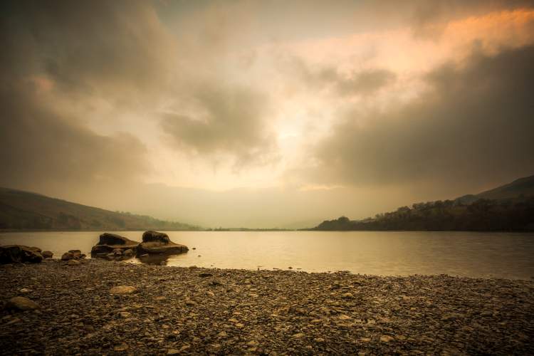
Lake Semerwater

History: Lake Semerwater, the second largest natural lake in North Yorkshire, is steeped in legend and beauty, offering a tranquil retreat in the heart of Raydale.
Google Maps Link: Lake Semerwater on Google Maps
Key Features and Interest: The lake is surrounded by hills and fields, offering stunning reflections and a peaceful atmosphere. It’s a haven for wildlife, including various bird species.
Why Photographers Should Visit: This location is perfect for landscape and wildlife photography. The serene waters of the lake, especially during sunrise or sunset, provide a captivating backdrop for stunning compositions.
Stalling Busk
History: Stalling Busk is a small, tranquil village in Raydale, known for its old chapel and quiet rural setting.
Google Maps Link: Stalling Busk on Google Maps
Key Features and Interest: The village exudes a sense of peace and timelessness, with traditional Yorkshire Dales architecture and scenic views of the surrounding countryside.
Why Photographers Should Visit: Stalling Busk is ideal for those seeking to capture the quintessential charm of a Yorkshire Dales village. Its pastoral landscapes and historic buildings offer a range of photographic opportunities.
Countersett
History: Countersett, nestled in Raydale, is a small hamlet known for its picturesque setting and traditional stone-built houses.
Google Maps Link: Countersett on Google Maps
Key Features and Interest: The hamlet is surrounded by rolling hills and farmland, providing a peaceful and idyllic rural scene.
Why Photographers Should Visit: Countersett offers a tranquil environment for capturing the essence of rural life in the Dales. The hamlet’s scenic beauty and traditional architecture make it a great subject for landscape and architectural photography.
Marsett
History: Marsett, a small village in Raydale, is a hidden gem, offering a glimpse into the serene and unspoiled nature of the Yorkshire Dales.
Google Maps Link: Marsett on Google Maps
Key Features and Interest: The village is characterized by its traditional Dales cottages and its proximity to the River Bain, England’s shortest river, which flows into Lake Semerwater.
Why Photographers Should Visit: Marsett is perfect for photographers who appreciate the quiet and untouched aspects of the Dales. The combination of quaint village life and the natural beauty of the river and lake surroundings offers diverse photographic subjects.
Kingsdale – A Valley of Dramatic Landscapes and Speleological Wonders

Ingleborough Cave
History: Ingleborough Cave, a show cave in Kingsdale, was first discovered in the 19th century and has since been a site of significant geological interest.
Google Maps Link: Ingleborough Cave on Google Maps
Key Features and Interest: The cave is known for its impressive stalactites and stalagmites, and the guided tours offer insights into its geological formations and history.
Why Photographers Should Visit: It’s an exceptional location for photographers interested in capturing the unique and otherworldly interior landscapes of caves. The play of light on the rock formations creates a fascinating photographic subject.
Kingsdale Head

History: Kingsdale Head is a remote part of the valley, offering a sense of isolation and unspoiled natural beauty.
Google Maps Link: Kingsdale Head on Google Maps
Key Features and Interest: The area is characterized by its dramatic limestone pavements and sweeping views of the surrounding hills and dales.
Why Photographers Should Visit: For landscape photographers, Kingsdale Head provides a rugged and raw backdrop, ideal for capturing the dramatic essence of the Yorkshire Dales. The limestone pavements are especially photogenic in the changing light of dawn and dusk.
Valley Entrance

History: The Valley Entrance is the gateway to the Kingsdale Valley, offering a dramatic introduction to the area’s rugged terrain and natural beauty.
Google Maps Link: Valley Entrance on Google Maps
Key Features and Interest: The entrance provides a sweeping view of the valley, showcasing its limestone cliffs, green pastures, and traditional stone walls.
Why Photographers Should Visit: This location offers a panoramic view of Kingsdale, ideal for capturing wide landscape shots. The contrast between the rugged cliffs and the pastoral valley floor provides a diverse range of photographic opportunities.
Deepdale – A Realm of Untouched Beauty and Tranquil Landscapes

Deepdale Beck
History: Deepdale Beck is a charming stream that flows through the heart of Deepdale, known for its clear waters and serene surroundings.
Google Maps Link: Deepdale Beck on Google Maps
Key Features and Interest: The beck meanders through lush meadows and past stone walls, typical of the Yorkshire Dales landscape, offering a picturesque and peaceful setting.
Why Photographers Should Visit: It’s an ideal location for capturing the tranquil and unspoiled nature of Deepdale. The beck, with its clear waters and surrounding greenery, provides a perfect subject for landscape and nature photographers.
Cam High Road

History: Cam High Road is an ancient Roman road that traverses the hills of Deepdale, offering a glimpse into the area’s historical significance.
Google Maps Link: Cam High Road on Google Maps
Key Features and Interest: This historic route offers expansive views of Deepdale and beyond, showcasing the rolling landscapes and wide skies of the Dales.
Why Photographers Should Visit: The road is perfect for capturing the dramatic landscapes of the Dales, with its elevated position offering panoramic views. The historical aspect of the Roman road adds depth to landscape photography.
Beckermonds
History: Beckermonds is a small hamlet in Deepdale, situated at the point where the rivers Wharfe and Oughtershaw Beck meet.
Google Maps Link: Beckermonds on Google Maps
Key Features and Interest: The meeting of the two rivers in this scenic hamlet provides a charming natural spectacle. The traditional stone cottages and rural setting enhance its picturesque quality.
Why Photographers Should Visit: Beckermonds offers a unique opportunity to photograph the convergence of two rivers in a quintessentially rural Yorkshire setting. It’s a tranquil spot for capturing both the dynamic flow of water and the quiet beauty of the hamlet.
Deepdale Head

History: Deepdale Head is a remote part of the valley, known for its wide-open landscapes and the sense of solitude it offers.
Google Maps Link: Deepdale Head on Google Maps
Key Features and Interest: The area is characterized by its expansive moorlands, rugged terrain, and sweeping views of the surrounding countryside.
Why Photographers Should Visit: Deepdale Head is a haven for landscape photographers looking for unspoiled vistas. The vast open spaces and the play of light across the moors provide endless possibilities for capturing the wild beauty of the Dales.
Chapel-le-Dale – A Valley of Striking Views and Historical Significance
Ingleton Waterfalls Trail

History: The Ingleton Waterfalls Trail is a famous walking route in Chapel-le-Dale, renowned for its spectacular series of waterfalls and woodland scenery.
Google Maps Link: Ingleton Waterfalls Trail on Google Maps
Key Features and Interest: The trail offers stunning views of waterfalls like Thornton Force and Pecca Falls, set against the backdrop of ancient woodlands and rugged cliffs.
Why Photographers Should Visit: It’s an ideal location for capturing the dynamic beauty of waterfalls and the serene charm of woodlands. Each turn of the trail provides new and exciting photographic opportunities, from grand landscapes to intimate nature shots.
Twisleton Scar
History: Twisleton Scar is a notable limestone area in Chapel-le-Dale, characterized by its rugged terrain and panoramic views.
Google Maps Link: Twisleton Scar on Google Maps
Key Features and Interest: The area is known for its striking limestone pavements and expansive views over the valley and towards Ingleborough, one of the Three Peaks.
Why Photographers Should Visit: The limestone formations at Twisleton Scar provide a unique landscape for photography. The textures and patterns of the rock, coupled with the wide views, make it a compelling subject for landscape photographers.
Ribblehead
History: Ribblehead, located in Chapel-le-Dale, is famous for the Ribblehead Viaduct, an iconic structure on the Settle-Carlisle railway line.
Google Maps Link: Ribblehead on Google Maps
Key Features and Interest: The viaduct, with its 24 stone arches, stretches across the valley against the dramatic backdrop of the Yorkshire Dales. The surrounding area is rich in natural beauty and historical interest.
Why Photographers Should Visit: Ribblehead Viaduct is a must-visit for its architectural grandeur and scenic setting. It offers photographers a chance to capture a piece of Victorian engineering amidst the natural beauty of the Dales.
Philpin Lane
History: Philpin Lane is a country lane in Chapel-le-Dale, offering picturesque views of the rural landscape and traditional farming life.
Google Maps Link: Philpin Lane on Google Maps
Key Features and Interest: The lane winds through fields and past stone walls, with views of sheep grazing and the rolling hills of the Dales.
Why Photographers Should Visit: Philpin Lane is perfect for capturing the essence of the Yorkshire Dales’ rural landscape. The lane and its surroundings offer a peaceful setting for photography, showcasing the beauty of the English countryside.